Table of Contents
What Is a GPS Grading System?
A GPS grading system can be implemented on more than just skid steers and dozers. These systems are also commonly used on excavators, motor graders, compact track loaders, and even some backhoes. The technology is flexible and scalable, making it suitable for both heavy earthmoving and precision finish work across a wide range of equipment types. A GPS grading system uses satellite positioning to guide construction equipment as it cuts, fills, and grades a site. These systems are installed on machines like skid steers and dozers, giving operators a real-time display of grade targets, design elevations, and slope control.
Instead of relying on stakes and stringlines, operators use GPS data to hit exact grades with speed and precision. This reduces the need for rework and improves overall jobsite efficiency.
Contractors using a GPS grading system can save significant time and money by reducing rework, minimizing overdig, and improving communication between field crews and project managers. As construction timelines tighten, the ability to get grade right the first time is more valuable than ever.
How It Works
A typical GPS grading system includes:
- Base Station or Correction Source: Provides a known reference point to improve GPS accuracy
- GNSS Antennas and Receivers: Mounted on the machine to track its exact position
- Control Box/Display: Shows the operator where they are in relation to the design
- Machine Sensors: Adjust blade or bucket height to maintain grade
Some systems also integrate with 3D machine control models, giving operators a visual map of the design surface right in the cab. This helps ensure that every pass is on target, and it gives less experienced operators a better sense of the terrain.
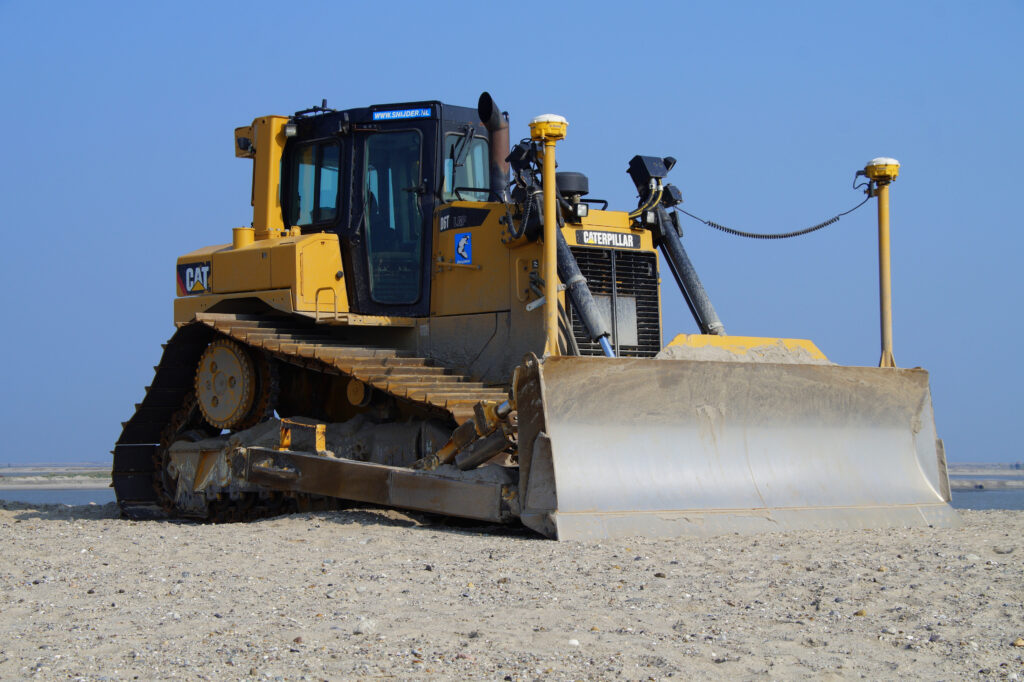
GPS Grading for Dozers
Dozers are one of the most common machines to use a GPS grading system. With wide blades and high pushing power, they’re ideal for rough grading, building pads, and large-scale cut/fill work.
Using a GPS dozer:
- Reduces reliance on grade checkers
- Speeds up mass excavation and pad prep
- Improves pass efficiency and slope accuracy
- Allows for faster project completion with less manual checking
Dozers often operate with dual antenna systems to maintain blade position and cross-slope control. This is especially useful on roadways, building pads, or any site with complex elevation transitions.
GPS Grading for Skid Steers
Skid steers equipped with GPS grading systems are a game-changer for smaller sites and tight areas. They can handle:
- Fine grading around curbs and sidewalks
- Parking lot pads
- Landscape and hardscape base prep
- Tight spaces where large dozers can’t maneuver
A skid steer GPS system might use a mastless solution or connect to a grading box with integrated sensors. These compact machines benefit from GPS-guided equipment because it helps eliminate manual guesswork and enables one operator to do the work of two or three.

2D vs. 3D Systems
- 2D GPS systems control only elevation, often using a laser plane or sonic tracer. They’re ideal for flatwork like parking lots or concrete pads.
- 3D GPS systems include full elevation and slope control, using a digital 3D model of the site design. These are preferred for sites with changing contours, drainage swales, or split-level pads.
Many contractors start with a 2D GPS grading system and upgrade to 3D as their workflow, crew size, or project complexity grows. 3D systems require a machine control model, which replicates the design in digital format.
Benefits of GPS Grading Systems
- Increases grading accuracy: Reduces deviation from design grade
- Speeds up production: Fewer passes needed to hit spec
- Minimizes rework: Fewer callbacks and corrections
- Improves safety: Reduces the need for workers near moving equipment
- Reduces material waste: Less overcutting, undercutting, or overfill
- Supports less experienced operators: GPS grading gives them clear guidance
By enabling operators to work more efficiently and accurately, a GPS grading system also helps contractors maintain tighter schedules and improve overall jobsite coordination.
Is It Worth It?
For many contractors, investing in a GPS grading system quickly pays off. Projects get done faster, with fewer mistakes and less material waste. These systems also make it easier to scale operations without needing more crew members.
Rental options, used systems, and entry-level packages make GPS technology more accessible than ever. Smaller contractors who once viewed GPS as out of reach can now adopt it affordably—and see major gains.
Plus, technology like Trimble Earthworks, Topcon MC-Mobile, and Leica iCON has made setup simpler and interfaces more user-friendly. With mobile displays, cloud syncing, and portable base stations, GPS grading can be deployed in the field in under an hour.

Choosing the Right System
When selecting a GPS grading system, consider:
- Machine types (dozer, skid steer, excavator)
- Frequency of model changes or design updates
- Site conditions and drainage needs
- Project size and complexity
- Budget and long-term support needs
Some contractors prefer fully integrated OEM systems, while others go with aftermarket add-ons that can be moved between machines. Make sure your choice matches the scale and scope of your typical jobs.
We Can Help You Get Started
At TCL Consulting, we build accurate machine control models for GPS grading systems. Whether you run a dozer, skid steer, or both—we deliver clean, tested models that make your equipment more productive.
Our team understands how to structure site data, grading layers, and pad elevations to match field needs. We also catch plan issues early to avoid rework later. If you’re just starting with GPS-guided equipment, we can connect you with trusted partners to help source and install your system.
Contact Us to learn more or request a quote today.